
Archive Record
Images
Metadata
Catalog Number |
2025.002.20 |
Object Name |
Plan, Site |
Reference code |
US SPHi 2025.002.20 |
Date |
1896 |
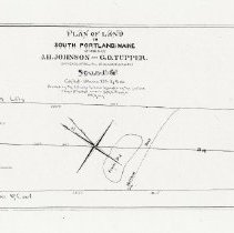
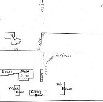
Scope & Content |
1896 plan of land in Thornton Heights, South Portland, Maine, owned by John H. Johnson and Gideon O. Tupper. Plan filed on May 20, 1896, at the Cumberland County Registry of Deeds, plan book 8, page 39. Detail from plan showing the John H. Johnson farmhouse, barn, shed, wash house, celery house, and pig house. The 15-acre property was bordered by Main Street, the William Libby property, the Boston & Maine Railroad, and the Charles McCourt property. The Gideon Tupper property was sold to Albert J. McLean in 1900. The property was later subdivided and McLean Street runs through it. The John H. Johnson property was sold to Archie Carignan in 1940. The property was later subdivided and Carignan Avenue runs through it. |
Search Terms |
McLean Street Carignan Avenue |
People |
Johnson, John H. (farmer, 1864-1942, son of James and Betsey) |