
Archive Record
Images
Metadata
Catalog Number |
2017.097.2 |
Object Name |
Survey, Land |
Reference code |
US SPHi 2017.097.2 |
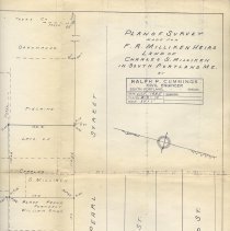
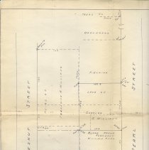
Scope & Content |
Land survey or site plan showing the layout of properties in the Elm Street, Pearl Street and Chestnut Street area of South Portland. The land of Charles S. Milliken. Plan was drawn by Ralph P. Cummings, Civil Engineer, in July, 1935, for the heirs of F.A. Milliken. The lot on the corner of Elm and Pearl Street, 148 Elm Street, formerly belonged to William Ames. The lot on the corner of Elm and Chestnut Street, 136 Elm Street, formerly belonged to Sarah Rogers, and later to Glendon and Marjorie Swett. |
Search Terms |
Elm Street Pearl Street Chestnut Street |