
Archive Record
Images
Metadata
Catalog Number |
2016.004.23 |
Object Name |
Plan, Site |
Reference code |
US SPHi 2016.004.23 |
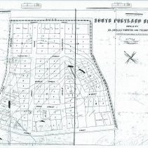
Scope & Content |
Plan for South Portland Heights, land owned by Colonel Charles C.G. Thornton and F.H. Harford. The land is not actually in the neighborhood called South Portland Heights, but rather the land at Spring Point adjacent to Fort Preble. Jefferson Street is actually Broadway. Shows land bounded by Broadway, Benjamin W. Pickett Street and Fort Road. |
Search Terms |
Willard Fort Road Surfsite Road |
People |
Harford, Frederick H. Thornton, Charles C.G. |
Extent of Description |
Housed with street plans for the Willard neighborhood. |