
Archive Record
Images
Metadata
Catalog Number |
2010.096.30 |
Collection |
Harry E. Baker Company Collection |
Object Name |
Plan, Site |
Reference code |
US SPHi 2010.096.30 |
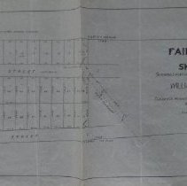
Title |
Fairmount sketch |
Date |
1926 |
Scope & Content |
Sketch showing the location of property of William O. Lewis in Thornton Heights. Land has been shown as a subdivision with properties along Cornell Street, Hayden Street, and Main Street. Traced from a 1909 blueprint in possession of Elizabeth P. Lewis with additions of Portland Terminal Company purchase and New England Telephone and Telegraph pole rights. Sketch by Ralph P. Cummings, civil engineer, dated March 15, 1926. |
Search Terms |
Cornell Street Memory Lane (formerly Hayden Street) Thornton Heights |
Subjects |
Developments, Housing Real estate development |