
Archive Record
Images
Metadata
Catalog Number |
2025.013.1 |
Object Name |
Map |
Reference code |
US SPHi 2025.013.1 |
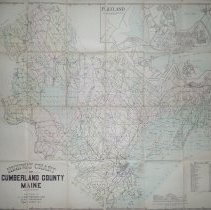
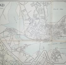
Title |
Highway Chart of Cumberland County, Maine |
Date |
Circa 1900 |
Scope & Content |
Cloth-backed map, Highway Chart of Cumberland County, Maine, published by L.J. Richards Company, cartographers, Pawtucket, RI. Map identifies all of the highways, electric railways, street railways, state and county lines, churches, schools, railway stations, streams, and lighthouses. Inset map of Portland and South Portland. Map is undated but includes a listing of the population of each city and town in 1900. |
Search Terms |
Cumberland County |
Subjects |
Highways |
Extent of Description |
34.75" x 32" |